Saturday, December 29, 2018

Tobacco census 1910 - J. B. Coffman


James Buchanan (Buck) Coffman was born 28 Jan 1857 and died 8 Jan 1935; he is buried in Point Pleasant Cemetery, Ohio County. 

Wednesday, December 26, 2018

Tobacco census 1910 - William S. Carter


William Silas Carter  was born 14 Feb 1876 and was a farmer in the Centertown area of Ohio County. He never married and died 17 Mar 1947 at age 71. He is buried in Waltons Creek Church Cemetery in Centertown.

Saturday, December 22, 2018

Tobacco census 1910 - Thomas L. Bradley


Thomas Logan Bradley lived in Cromwell. He was born 3 March 1866 and died 22 Apr 1917. 


Wednesday, December 19, 2018

Tobacco census 1910 - Thomas J. Bishop

Thomas J. Bishop was born 25 Mar 1855 and died 30 Dec 1920. He lived in Matanzas, Ohio County.


Saturday, December 15, 2018

Tobacco census 1910 - Calvin C. Borah

In August 1910 the Federal government collected data about the production of tobacco in the various states. A form was mailed to individuals and was filled out and returned to the Census Bureau. I found that fourteen people from Ohio County returned a tobacco census form.  Unfortunately the quality of these documents is not very good, some of the hand writing is hard to read, and the information contained in the documents is not earth-shaking but, none-the-less, it might be important to a descendant. I will post them in alphabetical order - the first is Calvin C. Borah.


Calvin Borah was born in 1845 so at the time he filled out this form he was 65 years old. The regular census for 1910 says he lived in Cromwell and was a timber dealer. Calvin lived until 1930. Page one above says that he leased the property where he had a tobacco crop (tenant).

Wednesday, December 12, 2018

Owen Hunter and Oppie Kittinger


This is a photo of Owen Hunter (center in overalls) and Oppie Kittinger (left) with cigars.  The man on the right is unidentified.  Hunter and Kittinger were related by marriage.  The photo was taken at Livermore or Hartford during 1910 - 1920.  The photo was contributed to the Kentucky Historical Society by Carmen Kittinger.

Saturday, December 8, 2018

John P. C. Porter

I have only found one Porter family in the 1840 census for Ohio County - it looks like the father was named Oliver or Elvira Porter (probably Oliver Cromwell Porter 1784-1858). I think this is correct and I think the son shown in the above chart was John Philpot Curran Porter born about 1824 (chart says he is 19 years old, so that would be 1821 or so.

Wednesday, December 5, 2018

Stateler Memorial Methodist Church


Stateler Memorial Methodist Church

Willow Creek Methodist Church, 303 Main Street, Willow Creek, Gallatin County, Montana.

Placed on the Register of Historic Places June 2008.  Built in 1915. Named after Rev. Learned Blackman Stateler from Ohio County, Kentucky.


Saturday, December 1, 2018

1940 Census Maps

The 1940 census maps might help you find where your ancestors lived and what church, school or cemetery was nearby. Ohio County was split into 23 enumeration districts (92-1 to 92-23). A person was paid to visit every house in the district within a one month period. The following maps are only for the 1940 census and different maps were probably used for earlier years. Note that the maps also show "Magistrate Districts" which are political districts - a Magistrate is the same as a Justice of the Peace (each county in Kentucky is divided into 3 to 8 Magistrate Districts). You can zoom on these maps to a very fine detail and see the names of creeks and symbols for homes, churches, and other buildings. The "legend" for these symbols is found on Map 2 in the lower left corner. Population is shown for some towns; for example, the first map shows the population of Fordsville to be 570. Actually, Map 2 discloses that this is actually a 1937 map prepared by the KY Department of Highways; so the Census office used a 1937 map and added their information by hand for the 1940 census.
When you find your ancestor listed on the census sheets you will see that the far left column is for the name of the street or road they lived on and the next column is for their street number. Of course in rural areas street numbers were not used in 1940. If nothing is shown for location then the person that prepared the document failed to fill it out completely, which is often the case. In the upper right of each page the Enumeration District is shown, which corresponds to the maps. Each page is dated and signed by the person that took the census.  If you are lucky your ancestor is listed on line 4 or 40 - if so, look at the supplementary information at the bottom of the page.  So, find your ancestor and then use the maps to try to pin-point their location and see what was nearby.  If you are a member of Ancestry.com you can see these same maps and those maps may have better detail for viewing on your computer. 

Here are the six maps that show all of the 23 enumeration districts:


Wednesday, November 28, 2018

Sunday, November 11, 2018

Kentucky WWI


This is a Service flag or Service banner, also called the Blue Star Flag or Mother's War Banner. It is machine-stitched, and it is made of wool bunting with a canvas header. The banner has a white field with a 12-inch wide red border. The white field is made of two vertical segments of fabric that are stitched together down the center. There is an appliquéd blue star at the top center of the field with blue appliquéd "103,000" below the star. In the center of the field, there is red appliquéd letters that read, "WWI / KENTUCKY." The bottom half of the field has a yellow or gold star appliquéd onto the field with a gold number "3,200" appliquéd below the star. The red border is made of four panels of fabric stitched to the field. The seams are stitched with white thread. This banner has a canvas header with a rope strung through the sleeve. The rope is stitched in place. The rope is looped on the right end and a 30-inch segment of rope hangs off the left side of the banner. On the back of the right side of the header, there is an inscription that reads, "KY. CHAPTER / AMERICAN WAR MOTHERS / 1927."

Size is 74" x 48.5"

The numbers on the banner apparently means 103,000 Kentuckians served in World War I and 3,200 died.  These figures might not be correct - see https://www.abmc.gov/news-events/news/hometown-boys-kentucky-information-and-statistics-about-wwi-service-members


The above is Courtesy of Kentucky Historical Society.

As for Ohio County, my search found the following:

D.W. = Died of Wounds
D.D. = Died of Disease
D.A. = Died of Accident
K.A. = Killed in Action
W.A. = Wounded in Action

Saturday, November 10, 2018

Daviess County History - Sudie J. Tichenor, wife of James H. Davis

Source Daviess County History:


Also, note that a sister of Mr. Davis, Elminah E. Davis, married Randolph Wimp of Ohio County.

Monday, November 5, 2018

Voting in Kentucky

A short YouTube video from the Kentucky Historical Society about the history of voting in Kentucky:

https://www.youtube.com/watch?v=GG1I1kuYhcs


Sunday, November 4, 2018

1918 Flu Pandemic

My Leach grandfather, Harney Leslie Leach (1877-1918), and my great-grandfather, Samuel William Leach (1851-1918), both died in Ohio County in 1918 from the flu pandemic.  This year is the 100th anniversary of that terrible time.

Remembering the 1918 Influenza Pandemic

This year marks the 100th anniversary of the 1918 influenza (flu) pandemic that swept the globe in what is still one of the deadliest disease outbreaks in recorded history. 
It is 
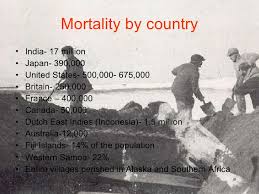
estimated that about 500 million people or one-third of the world’s population became infected with this virus, and the number of deaths was estimated to be at least 50 million worldwide with about 675,000 occurring in the United States. The pandemic was so severe that from 1917 to 1918, life expectancy in the United States fell by about 12 years, to 36.6 years for men and 42.2 years for women. There were high death rates in previously healthy people, including those between the ages of 20 and 40 years old, which was unusual because flu typically hits the very young and the very old more than young adults.

The Emerging Pandemic

The 1918 flu pandemic occurred during World War I; close quarters and massive troop movements helped fuel the spread of disease.
In the United States, unusual flu activity was first detected in military camps and some cities during the spring of 1918. For the U.S. and other countries involved in the war, communications about the severity and spread of disease was kept quiet as officials were concerned about keeping up public morale, and not giving away information about illness among soldiers during wartime. These spring outbreaks are now considered a “first wave” of the pandemic; illness was limited and much milder than would be observed during the two waves that followed.

Deadly Second Wave and Third Waves

In September 1918, the second wave of pandemic flu emerged at Camp Devens, a U.S. Army training camp just outside of Boston, and at a naval facility in Boston. This wave was brutal and peaked in the U.S. from September through November. More than 100,000 Americans died during October alone. The third and final wave began in early 1919 and ran through spring, causing yet more illness and death. While serious, this wave was not as lethal as the second wave. The flu pandemic in the U.S. finally subsided in the summer of 1919, leaving decimated families and communities to pick up the pieces. Scientists now know this pandemic was caused by an H1N1 virus, which continued to circulate as a seasonal virus worldwide for the next 38 years.

Limited Care and Control Efforts in 1918

In 1918, scientists had not yet discovered viruses so there were no laboratory tests to diagnose, detect, or characterize flu viruses. Prevention and treatment methods for flu were limited. There were no vaccines to protect against flu virus infection, no antiviral drugs to treat flu illness, and no antibiotics to treat secondary bacterial infections like pneumonia. Efforts to prevent the spread of disease were limited to non-pharmaceutical interventions (NPIs), including promotion of good personal hygiene, and implementation of isolation, quarantine, and 
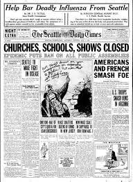
closures of public settings, such as schools and theaters. Some cities imposed ordinances requiring face masks in public. New York City even had an ordinance that fined or jailed people who did not cover their coughs.
Image result for 1918 flu pandemic   Image result for 1918 flu pandemic  Image result for 1918 flu pandemic